One of the key factors on transportation infrastructure improvement is the effective traffic decongestion, reduction of CO2 emissions, reduction of travel time and of fuel consumption. The computing of traffic flow reconstruction is at the basis of a large number of traffic infrastructure computations and optimizations such as: routing constrained on traffic conditions, computation of crossroad cycling, computation of the match from offer of transportation and the demand of mobility, and thus of what if analysis and optimization. Snap4City is a platform designed for decision maker to perform activities of operation and plan in the cities and at the support of control rooms. The project is founded on the CN MOST, PNRR, and by its Scalability subproject SASUAM.
Main text
One of the key factors on transportation infrastructure improvement is the effective traffic decongestion, reduction of CO2 emissions, reduction of travel time and of fuel consumption. These activities are addressed as optimization problems in which the functional is a combination of the mentioned goals. They estimation depend on the actual traffic flow distribution, the knowledge about the graphs and about the typical distributions at the crossroads. The scientific research towards mitigating traffic congestion focuses on multiple aspects and they can be classified into two main categories. Solutions that (a) work within the existing road infrastructure such as navigation routing algorithms for trip route optimization, public transport services planning, and (b) those that aim at modifying the existing transportation infrastructure itself (changing the road graph structure as well as the semaphore cycles). Solutions (a) in support of the infrastructure may impact specific users (public transport, drivers that use routing applications, etc...), impacting overall mobility indirectly. Modifying the infrastructure, as in (b), would require investments from cities and would impact would affect all road users. The effectiveness applications of (b) solutions can be found in the case study of New York City when in 2009 traffic congestion was reduced by utilizing the taxi GPS data to identify the critical congestion points of the city. Simulation tools for assessing the impact of road modifications on traffic distribution are of key relevance for city decision-makers to improve urban mobility and reduce emissions. Most of the available solutions are agent-based in which a set of agents/vehicles travel in a simulated road network environment, as in SUMO, PTV tools. The traffic flow simulated in the whole network is taken as a reference of the actual flow and can be better calibrated using some sensors data. On the other hand, thanks to the development of Internet of Things (IoT), it is possible to monitor traffic data in terms of vehicle flow (number of cars per hour) or vehicle density (number of cars per kilometer) in a number of relevant points. Then, by using traffic flow reconstruction, TFR, algorithms it is possible to compute the traffic flow in all the whole road network segments in real time using neuro-symbolic approaches [1], avoiding trusting on virtual simulations. The traffic flow reconstruction represents the real status of the road network at a specific time and can be exploited in a decision-support system to monitor the precise mobility within the city area or part of it (as a scenario).
The computing of TFR is at the basis of a large number of traffic infrastructure computation and optimization such as: routing constrained on traffic conditions, computation of crossroad cycling, computation of the match from offer of transportation and the demand of mobility, and thus of what if analysis and optimization (see Figure 1). Recently these activities traditionally performed by agent-based simulators are also domain for smarter Artificial Intelligence based solutions at the support of decision makers.
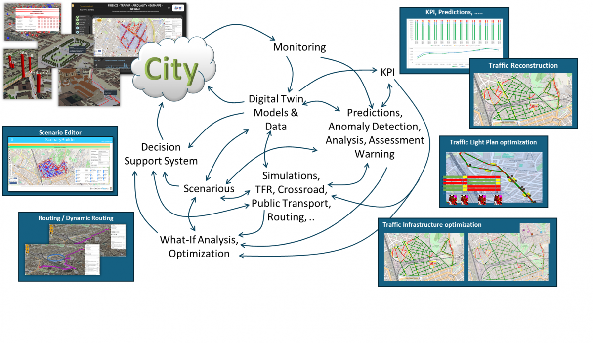
Figure 1: SASUAM Platform architecture for transportation infrastructure optimisation.
The main motivations optimization and what-if analysis targets are the decongestions of traffic and services, improvement of quality of public transportation services, and the quality of life. For example, traffic decongestion can be obtained by reducing the number of vehicles in crowded conditions, which also implies the reducing of emissions, changing/forcing the routing, optimizing the semaphore cycles, etc.; making mobility services more accessible would be obtained by providing more rides or different paths of public transportations and in some cases increasing emissions and expenses. Thus, tradeoff among conflicting targets have to be identified. For this reason, a scenario editor is provided [2], and a large range of interactive visualization tools have to be used for showing the effects and results to work with the decision makers and collect from them final decision and eventually suggestions in short time [3].
At page https://www.snap4city.org/997 a list of artificial intelligence Snap4City tools which can be compounded to set up solutions for decision makers in improving sustainability of their city is reported. Snap4City is a platform designed for decision maker to perform activities of operation and plan in the cities and at the support of control rooms. Snap4City is an open-source IoT platform coordinated by the DISIT Lab of the University of Florence. Snap4City is an official FIWARE and EOSC platform and it includes a set of Node-RED libraries. It is at present in operational use on several federated installations. The Snap4City platform is able to manage multiple tenants and billions of data per day with the key focus on interoperability, decision making, in operation and plan. Snap4City framework is applied in several smart cities and areas in Italy (Merano, Cuneo, Firenze, Lonato del Garda, etc.) and Europe (Malta, Rhodes, Varna, Limassol, Valencia, PontDuGard, Dubrovnik, Mostar, and West Greece, etc.), and in almost all continents. The largest installation of the platform is a multi-tenant managing advanced smart city IoT/IoE applications with 20 organizations, 40 cities and thousands of operators and developers.
The project is founded on the CN MOST, PNRR, and by its Scalability subproject SASUAM.
Links:
https://www.snap4city.org/997 AI and analytics
References:
[1] Bilotta, S., Bonsignori, V., & Nesi, P. (2023). High Precision Traffic Flow Reconstruction via Hybrid Method. IEEE Transactions on Intelligent Transportation Systems.
[2] L. Adreani, P. Bellini, S. Bilotta, D. Bologna, E. Collini, M. Fanfani, P. Nesi, "Smart City Scenario Editor for General What-if Analysis", Sensors, MDPI, 2024. https://www.mdpi.com/1424-8220/24/7/2225/pdf
[3] P. Bellini, M. Fanfani, P. Nesi, G. Pantaleo, "Snap4City Dashboard Manager: a tool for creating and distributing complex and interactive dashboards with no or low coding", SoftwareX, Elsevier, 2024. https://www.sciencedirect.com/science/article/pii/S2352711024001006 . https://doi.org/10.1016/j.softx.2024.101729
Please contact:
Paolo Nesi, University of Florence, DINFO, DISIT, Snap4City, Italy, paolo.nesi@unifi.it