Snap4City is a digital twin platform designed for decision maker to perform activities of operation and plan in the cities and control rooms. Planning means to assess the city condition in terms of contextual and historical data, the desiderata/objectives and goals/key-performance-indicators o provide support in planning, generating suggestions, solutions to the problems, etc. The ML/AI analytics are in most cases seamless for the decision makers which are receiving suggestions from AI also via some XAI annotations. Recently, the provision of interactive 3D digital twin models is actually requested by decision makers for its immediate representation to perceive an awareness of the situations, and to perform real time simulation of changes, estimating their effects in terms of KPI on decongestion, travel time, emissions, etc. The specific action is founded as CAI4DSA cascade project of FAIR PE on Future Artificial Intelligence, PNRR.
Main text
Snap4City is a digital twin platform designed for decision maker to perform activities of operation and plan in the cities and control rooms. Operation means at least to monitor, control, predicting and react in real time to current operational conditions and related events. For this purpose, data are collected, processed and early warning computed by using a range of data analytics and artificial intelligence processes. Planning means to assess the city condition in terms of contextual and historical data, the desiderata/objectives and goals/key-performance-indicators o provide support in planning, generating suggestions, solutions to the problems, etc. The operation is always an activity to be performed in real time, quasi real time, while the plan may take time. Recently, what-if analysis and optimization tools, typically applied on plan are also used on operation for fast reaction to critical conditions, and the time to plan has been strongly shortened. Snap4City provides an integrated solution for data gathering, indexing, computing, and information distribution, thus realizing a continuously updated digital twin of the urban environment at global and local scales for monitoring operation and planning. It addresses 3D building models, road networks, Internet of Things entities, points of interest, paths, as well as results from analytical processes for traffic density reconstruction, pollutant dispersion, predictions, and what-if analysis for assessing impact of changes, all integrated into a freely accessible interactive 3D web interface, enabling stakeholder and citizen participation to city decision processes.
The architecture of Snap4City is reported in Figure 1. The multidomain platform allows to collect and automatically process and represent complex data from of several different kinds. For example, traffic flow which are graph changing over time, origin destination matrices which are maps/graphs changing over time, time series, heatmaps, trajectories and routings, scenarios to be assessed, events and intervention of restoring in the city, etc. The more relevant domains which are presently strongly interconnected each other are: mobility and transport, environmental, energy. Snap4City is an open-source IoT platform coordinated by the DISIT Lab of the University of Florence. Snap4City is an official FIWARE and EOSC platform and it includes a set of Node-RED libraries. It is at present in operational use on several federated installations. The Snap4City platform is able to manage multiple tenants and billions of data per day with the key focus on interoperability, decision making, in operation and plan. Snap4City framework is applied in several smart cities and areas in Italy (Merano, Cuneo, Firenze, Lonato del Garda, etc.) and Europe (Malta, Rhodes, Varna, Limassol, Valencia, PontDuGard, Dubrovnik, Mostar, and West Greece, etc.), and in almost all continents. The largest installation of the platform is a multi-tenant managing advanced smart city IoT/IoE applications with 20 organizations, 40 cities and thousands of operators and developers.
The main drivers for sustainability are the decongestions of traffic and services, decarbonization, improvement of services’ accessibility and of security/safety, and may be the improvement of quality of life. For example, (i) traffic decongestion can be obtained by reducing the number of cars on stop and go conditions, this would also implies to reducing the emissions but depending on the kind of vehicles are typically in the city, thus stimulating the decarbonization with e-vehicles diffusion (the actual solutions could be several, from changing the transportation infrastructure, at optimizing the semaphore cycles, etc.); (ii) making mobility services more accessible would implies to have more rides or different paths of public transportations and in some cases increasing emissions; (iii) reducing the critical conditions could improve safety, may be at the expense of monitoring more carefully all the city areas and thus spending more energy and computational power. At page https://www.snap4city.org/997 a list of artificial intelligence (AI, explainable AI, XAI tools) Snap4City tools which can be compounded to set up solutions for decision makers in improving sustainability of their city is reported.
The first step of those activities is the data ingestion and modeling, field interoperability and data processing area capabilities for collecting data from any sources and exchanging data in push toward any brokers, gateways, and services. This area is interoperable with a large number of protocols and formats and enabling federation of smart cities. Real-time data, as well as event driven streams, are ingested using IoT brokers and indexed and shadow stored into a graph database (based on Km4City ontology, and data model for digital twins) and time series storage cluster, thus making them accessible to other consumer processes and brokers. Internal brokers are based on Orion Broker NGSI (also compatible with smart data models, and data spaces). Data can be retrieved in push or in an event driven way. Node-RED flows are used to enable data interoperability with third party services such as: GIS (Geographic In-formation Systems), ITS (Intelligence Transport Systems), TV cam services, CKAN open data networks, BIM servers, social media, data gateways, etc. Specific libraries of microservices for data transformation has been developed and made freely available to develop custom made processing logic.
The ML/AI analytics are in most cases seamless for the decision makers which are receiving suggestions from AI also via some XAI annotations. Recently, the provision of interactive 3D digital twin models is actually requested by decision makers for its immediate representation to perceive an awareness of the situations, and to perform real time simulation of changes, estimating their effects in terms of KPI on decongestion, travel time, emissions, etc. The specific action is founded as CAI4DSA cascade project of FAIR PE on Future Artificial Intelligence, PNRR.
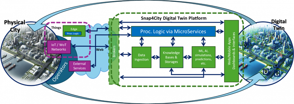
Figure 1: Snap4City Digital Twin conceptual architecture.
Links:
Https://www.snap4city.org
https://digitaltwin.snap4city.org
https://www.snap4city.org/997 AI and analytics
References:
[1] L. Adreani, P. Bellini, M. Fanfani, P. Nesi, G. Pantaleo, "Smart City Digital Twin Framework for Real-Time Multi-Data Integration and Wide Public Distribution", IEEE Access, IEEE, 2024. pp: 1-27, ISSN: 2169-3536, ISSN: 2169-3536, DOI: 10.1109/ACCESS.2024.3406795
[2] P. Bellini, M. Fanfani, P. Nesi, G. Pantaleo, "Snap4City Dashboard Manager: a tool for creating and distributing complex and interactive dashboards with no or low coding", SoftwareX, Elsevier, 2024. https://www.sciencedirect.com/science/article/pii/S2352711024001006 . https://doi.org/10.1016/j.softx.2024.101729