Urban traffic congestion and derived pollution represent critical challenges for sustainable city development. Snap4City presents a novel approach to optimize urban mobility infrastructure using a stochastic relaxation algorithm, which can be regarded as probabilistic reasoner to support decision makers. The method is designed to address the growing challenges of reducing traffic congestion, fuel consumption, and CO2 emissions in rapidly urbanizing cities. The system automates the generation and evaluation of road network modifications, drastically reducing the time and effort required for traditional simulation-based approaches. By utilizing real-time traffic data and traffic flow reconstruction algorithms within the Snap4City platform, the proposed system allows for the efficient exploration of "what-if" scenarios, and providing optimization support on the bases of key performance indicators such as travel time, fuel use, and CO2 emissions. A case study conducted in the city of Florence, Italy, demonstrates significant improvements in traffic conditions, fuel efficiency, and emissions reduction, underscoring the system's potential to enhance urban mobility in a sustainable manner. This system has been developed exploiting the Snap4City platform Scenario Editor and platform.
The solution automatically produces/computes a near-optimal solution in terms of suggested changes by minimizing the KPIs selected, and provides support to:
- specifies a scenario with geographic scope, designs the boundaries of the urban area, associates specific traffic data, period of observation, making changes if needed, etc.
- generates traffic data in all segments and time slots of any scenario (manually defined or generated).
- specifies and computes a set of KPI objectives: fuel consumption, congestion levels, CO2 emissions, and travel time over specific paths in the scenario.
- specifies constraints, such as: (i) roads to remain unchanged, (ii) changes on traffic flow data, to assess the effects of more critical conditions.
- optionally specifies the max number of changes that can be made by the optimization process to maintain any operational feasibility.
- supports the man in the loop, the operators may propose road changes. For example, starting from a modified scenario with additional changes with respect to actual conditions.
- generates a set of feasible improvements / changes to the road network and adhering to constraints and regulations, in agreement to the KPI chosen.
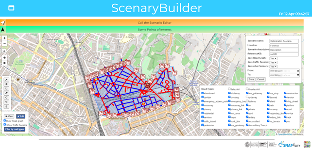
In the following figure, an example of the Snap4City Scenario Editor (Scenary Builder) which is accessible on all recent instances of the Snap4City platform. The older versions can be updated on request.
Read more on Scenario Editor on: https://www.snap4city.org/977
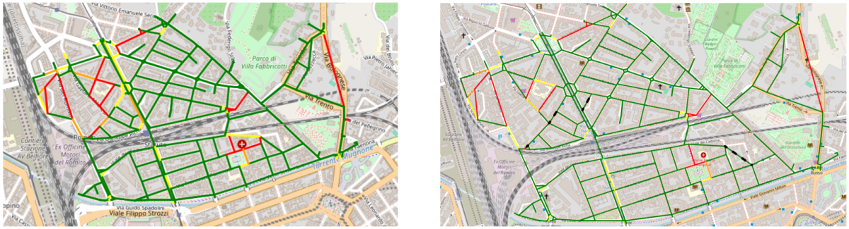
The framework proposed explores the solution space towards a near-optimal solution in a computationally efficient way via a stochastic relaxation optimization algorithm. Based on the need for this type of problem of limiting the number of changes in the transportation infrastructure to maximize the investments in terms of roads in congested states at peak hours, fuel consumption, and CO2 emissions, the system has been developed to be able to propose a modified scenario on a limited number of changes. The results reported a limited number of changes set to 4 on a middle urban city scenario improvement in terms of fuel consumption and CO2 emission in the range from 20% to 30% modifying some roads configuration (see the following figure, on the left the original conditions, and on right the solution with proposed changes. The changes are on roads marked with dashed lines). The solution has been designed to assess also the travel time on some specifiable main roads and enables the operator to set arbitrary unchangeable constraints to be flexible based on the requirements specific to the case study. The solution with the limited number of changes set to 4, proposed a road infrastructure configuration relaxing the initial solution towards improving the efficiency and environmental impact of the urban scenario considered.
The optimisation solution exploiting functionalities of the Open Source Snap4City platform allows operators to define an area via a polygon to define a scenario and test manually possible modifications to the road infrastructure in response to the requirements of municipalities and governments on improving the mobility on some parts of cities and urban context. The manual operation allows the operator to monitor specific objective functions that can be defined based on the traffic densities reconstructed exploiting the values from traffic sensors if present in the platform of typical time trends based on road category.
This result has been produced for the SASUAM scalability project, and for the OPTIFaaS Flagship project of CN MOST, the National Center on Sustainable Mobility in Italy (https://www.centronazionalemost.it/ ), and Snap4City as official infrastructure framework on which the experiments were conducted (https://www.snap4city.org). Snap4City is an open-source technology of DISIT lab.
This tool is accessible on Snap4City platform and some of its instances.
- This page: https://www.snap4city.org/1014
- SASUAM: Solutions for Safe, Sustainable and Accessible Urban Mobility
- OPTIFaaS: Operation and Plan, Transport Infrastructure and Facilities Support as a Service
- CN MOST: https://www.centronazionalemost.it/